CAZ103
There are no active watches, warnings or advisories

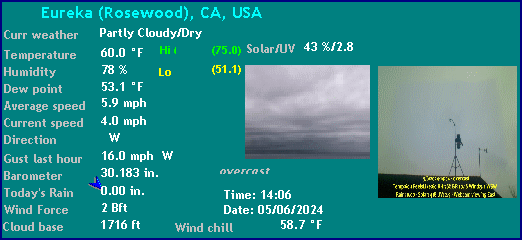
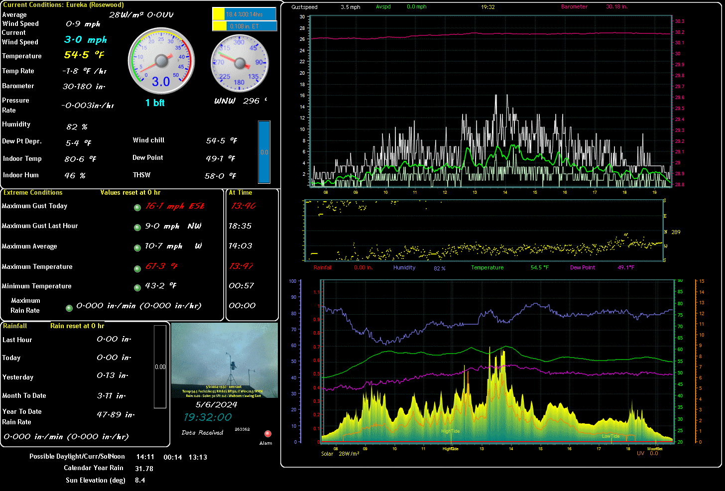
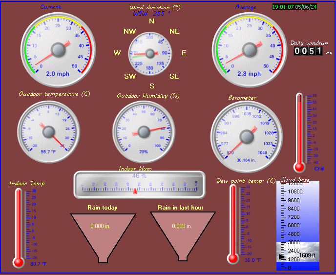
| Eureka (Rosewood) Weather Data | |||
|---|---|---|---|
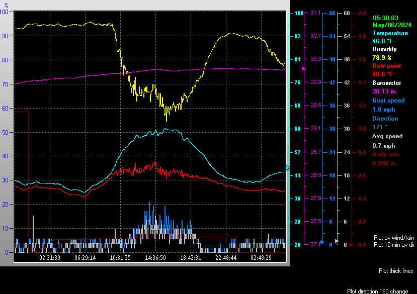
| LAST READING AT TIME: 04:47 DATE: April 26 2024, time of next update: 05:02 | |||
| Current Weather | Night time/overcast | Current Temperature | 50.8°F (10.4°C), Apparent temp 51.0°F |
| Maximum Temperature (since midnight) | 51.5°F at: 00:00 | Minimum Temperature (since midnight) | 50.7°F at: 04:14 |
| Average windspeed (ten minute) | 1.0 mph | Wind Direction (ten minute) | S (180°) |
| Windchill Temperature | 50.8°F | Maximum Gust (last hour) | 4.0 mph at: 03:55 |
| Maximum Gust (since midnight) | 10.4 mph at: 00:03 | Maximum 1 minute average (since midnight) | 7.1 mph at: 00:03 |
| Rainfall (last hour) | 0.01 in. (0.3 mm) | Rainfall (since midnight) | 0.10 in. (2.5 mm) at 03:49 |
| Rainfall This month | 1.28 in. (32.5 mm) | Rainfall To date this year | 44.68 in. (1134.9 mm) |
| Maximum rain per minute (last hour) | 0.01 in/min | Maximum rain per hour (last 6 hours) | 0.09 in/hour |
| Yesterdays rainfall | 0.15 in | DewPoint | 49.4°F (Wet Bulb :50.1°F ) |
| Humidity | 95 %, Humidex 52.8°F | Barometer corrected to msl | 30.048 in. (1017.5 hPa) |
| Pressure change | -0.02 in. (last hour) | Trend (last hour) | STEADY |
| Pressure change (last 12 hours) | -0.04 in | Pressure change (last 6 hours) | -0.01 in |
| Current Indoor Temp 77.9°F | |||
| Current Indoor Hum 46% | |||
| Current solar | 0 W/m² | Current UV | 0.0 |
| Maximum solar (since midnight) | 0 W/m² | Maximum UV (since midnight) | 0.0 |
| Current 00:00 hours of sunshine today, current sky: Night time/overcast | |||
| Sunshine hours for the year: | 284:16 hrs | Sunshine hours for the month: | 89:16 hrs |
| Current evapotranspiration 0.01 inches per day. Yesterday's reading 0.06 | |||
Expires:202404270130;;398850
FPUS56 KEKA 261025
ZFPEKA
Zone Forecast Product for California
National Weather Service Eureka CA
325 AM PDT Fri Apr 26 2024
This is an average forecast over a large and geographically diverse
area. For a specific forecast for your location...please refer to
the point and click forecast on our webpage at:
www.weather.gov/eureka.
Spot temperatures and probabilities of measurable precipitation
are for today, tonight, and Saturday.
CAZ101-270130-
Coastal Del Norte-
325 AM PDT Fri Apr 26 2024
.TODAY...Rain showers in the morning, then rain showers likely in
the afternoon. Highs 49 to 59. West wind up to 10 mph.
.TONIGHT...Mostly cloudy in the evening then becoming partly
cloudy. Slight chance of rain showers in the evening. Patchy fog
overnight. Lows 38 to 48. North wind around 10 mph.
.SATURDAY...Mostly cloudy. Patchy fog in the morning. Chance of
rain showers in the afternoon. Highs 50 to 60. Light winds
becoming southwest around 5 mph in the afternoon.
.SATURDAY NIGHT...Cloudy. Patchy fog. Chance of rain showers.
Lows 41 to 51. South wind around 10 mph.
.SUNDAY...Mostly cloudy. Slight chance of rain showers. Highs
52 to 62. West wind around 10 mph.
.SUNDAY NIGHT...Mostly cloudy. Slight chance of rain showers.
Lows 37 to 47.
.MONDAY...Mostly sunny. Slight chance of rain showers. Highs
53 to 63.
.MONDAY NIGHT...Mostly clear. Lows 36 to 46.
.TUESDAY THROUGH WEDNESDAY...Partly cloudy. Highs 56 to 67. Lows
36 to 46.
.WEDNESDAY NIGHT AND THURSDAY...Mostly cloudy. Chance of rain
showers. Lows 40 to 50. Highs 54 to 67.
&&
TEMPERATURE / PRECIPITATION
Crescent City 53 44 52 / 80 20 30
Klamath 56 42 58 / 80 20 30
$$
Expires:202404270130;;398851
FPUS56 KEKA 261025
ZFPEKA
Zone Forecast Product for California
National Weather Service Eureka CA
325 AM PDT Fri Apr 26 2024
This is an average forecast over a large and geographically diverse
area. For a specific forecast for your location...please refer to
the point and click forecast on our webpage at:
www.weather.gov/eureka.
Spot temperatures and probabilities of measurable precipitation
are for today, tonight, and Saturday.
CAZ102-270130-
Del Norte Interior-
325 AM PDT Fri Apr 26 2024
.TODAY...Rain showers and snow showers. Near steady temperature
in the lower 40s. Snow level 4500 feet. Snow accumulations up to
1 inch.
.TONIGHT...Mostly cloudy in the evening then becoming partly
cloudy. Chance of rain showers and snow showers in the evening.
Patchy valley fog overnight. Snow level 4500 feet. Lows 33 to 43.
.SATURDAY...Mostly cloudy. Patchy valley fog in the morning.
Chance of rain showers in the afternoon. Snow level 4000 feet.
Highs 42 to 57.
.SATURDAY NIGHT...Mostly cloudy. Slight chance of rain showers.
Lows 36 to 46.
.SUNDAY...Mostly cloudy. Highs 46 to 61.
.SUNDAY NIGHT AND MONDAY...Partly cloudy. Slight chance of rain
showers. Lows 32 to 42. Highs 47 to 62.
.MONDAY NIGHT...Mostly clear. Areas of frost. Lows 31 to 41.
.TUESDAY...Sunny. Highs 52 to 67.
.TUESDAY NIGHT AND WEDNESDAY...Partly cloudy. Lows 35 to 45.
Highs 54 to 69.
.WEDNESDAY NIGHT AND THURSDAY...Mostly cloudy. Chance of rain
showers. Lows 37 to 47. Highs 54 to 69.
&&
TEMPERATURE / PRECIPITATION
Gasquet 55 42 57 / 90 20 30
$$
Expires:202404270130;;398853
FPUS56 KEKA 261025
ZFPEKA
Zone Forecast Product for California
National Weather Service Eureka CA
325 AM PDT Fri Apr 26 2024
This is an average forecast over a large and geographically diverse
area. For a specific forecast for your location...please refer to
the point and click forecast on our webpage at:
www.weather.gov/eureka.
Spot temperatures and probabilities of measurable precipitation
are for today, tonight, and Saturday.
CAZ104-270130-
Southwestern Humboldt-
325 AM PDT Fri Apr 26 2024
.TODAY...Mostly cloudy. Rain showers likely in the morning, then
chance of rain showers in the afternoon. Highs 45 to 58.
Northwest wind 5 to 15 mph.
.TONIGHT...Mostly cloudy. Patchy fog overnight. Lows 38 to 48.
North wind 5 to 15 mph.
.SATURDAY...Mostly cloudy. Patchy fog in the morning. Slight
chance of rain showers in the afternoon. Highs 48 to 63.
Northwest wind 5 to 15 mph.
.SATURDAY NIGHT...Mostly cloudy. Lows 40 to 50. Northwest wind
around 10 mph.
.SUNDAY...Partly cloudy. Highs 51 to 66. Northwest wind 5 to
15 mph.
.SUNDAY NIGHT AND MONDAY...Partly cloudy. Lows 37 to 47. Highs
51 to 66.
.MONDAY NIGHT AND TUESDAY...Mostly clear. Lows 37 to 47. Highs
52 to 67.
.TUESDAY NIGHT AND WEDNESDAY...Partly cloudy. Lows 38 to 48.
Highs 54 to 69.
.WEDNESDAY NIGHT AND THURSDAY...Partly cloudy. Slight chance of
rain showers. Lows 39 to 49. Highs 54 to 69.
&&
TEMPERATURE / PRECIPITATION
Honeydew 54 42 58 / 60 10 20
$$
Expires:202404270130;;398854
FPUS56 KEKA 261025
ZFPEKA
Zone Forecast Product for California
National Weather Service Eureka CA
325 AM PDT Fri Apr 26 2024
This is an average forecast over a large and geographically diverse
area. For a specific forecast for your location...please refer to
the point and click forecast on our webpage at:
www.weather.gov/eureka.
Spot temperatures and probabilities of measurable precipitation
are for today, tonight, and Saturday.
CAZ105-270130-
Northern Humboldt Interior-
325 AM PDT Fri Apr 26 2024
.TODAY...Mostly cloudy. Rain showers in the morning, then chance
of rain showers in the afternoon. Near steady temperature in the
mid 40s. Snow level 4500 to 5000 feet.
.TONIGHT...Mostly cloudy. Slight chance of rain showers in the
evening. Patchy valley fog overnight. Snow level 4500 feet. Lows
34 to 44.
.SATURDAY...Mostly cloudy. Patchy valley fog in the morning.
Slight chance of rain showers in the afternoon. Snow level
4000 feet. Highs 48 to 63.
.SATURDAY NIGHT...Mostly cloudy. Slight chance of rain showers.
Lows 37 to 47.
.SUNDAY...Partly cloudy. Highs 53 to 68.
.SUNDAY NIGHT AND MONDAY...Partly cloudy. Lows 33 to 43. Highs
53 to 68.
.MONDAY NIGHT AND TUESDAY...Mostly clear. Lows 32 to 42. Highs
58 to 73.
.TUESDAY NIGHT AND WEDNESDAY...Partly cloudy. Lows 36 to 46.
Highs 61 to 76.
.WEDNESDAY NIGHT...Mostly cloudy. Slight chance of rain showers.
Lows 38 to 48.
.THURSDAY...Mostly cloudy. Chance of rain showers. Highs 54 to
69.
&&
TEMPERATURE / PRECIPITATION
Orleans 58 43 63 / 90 10 20
Hoopa 56 43 61 / 90 20 20
Willow Creek 58 43 63 / 90 10 20
$$
Expires:202404270130;;398855
FPUS56 KEKA 261025
ZFPEKA
Zone Forecast Product for California
National Weather Service Eureka CA
325 AM PDT Fri Apr 26 2024
This is an average forecast over a large and geographically diverse
area. For a specific forecast for your location...please refer to
the point and click forecast on our webpage at:
www.weather.gov/eureka.
Spot temperatures and probabilities of measurable precipitation
are for today, tonight, and Saturday.
CAZ106-270130-
Southern Humboldt Interior-
325 AM PDT Fri Apr 26 2024
.TODAY...Mostly cloudy. Rain showers likely in the morning, then
chance of rain showers in the afternoon. Snow level 4500 to
5000 feet. Highs 45 to 60.
.TONIGHT...Mostly cloudy in the evening then becoming partly
cloudy. Patchy valley fog overnight. Lows 34 to 44.
.SATURDAY...Partly cloudy in the morning then becoming mostly
cloudy. Patchy valley fog in the morning. Slight chance of rain
showers in the afternoon. Snow level 4000 feet. Highs 50 to 65.
.SATURDAY NIGHT...Mostly cloudy. Patchy valley fog. Lows 37 to
47.
.SUNDAY...Mostly sunny. Highs 53 to 68.
.SUNDAY NIGHT...Partly cloudy. Lows 33 to 43.
.MONDAY THROUGH TUESDAY...Mostly clear. Highs 56 to 71. Lows
33 to 43.
.TUESDAY NIGHT AND WEDNESDAY...Partly cloudy. Lows 35 to 45.
Highs 58 to 73.
.WEDNESDAY NIGHT AND THURSDAY...Partly cloudy. Slight chance of
rain showers. Lows 37 to 47. Highs 58 to 73.
&&
TEMPERATURE / PRECIPITATION
Garberville 58 41 63 / 60 0 0
$$
Expires:202404270130;;398852
FPUS56 KEKA 261025
ZFPEKA
Zone Forecast Product for California
National Weather Service Eureka CA
325 AM PDT Fri Apr 26 2024
This is an average forecast over a large and geographically diverse
area. For a specific forecast for your location...please refer to
the point and click forecast on our webpage at:
www.weather.gov/eureka.
Spot temperatures and probabilities of measurable precipitation
are for today, tonight, and Saturday.
CAZ103-270130-
Northern Humboldt Coast-
325 AM PDT Fri Apr 26 2024
.TODAY...Mostly cloudy. Rain showers in the morning, then chance
of rain showers in the afternoon. Highs 48 to 58. Northwest wind
up to 10 mph.
.TONIGHT...Mostly cloudy. Patchy fog overnight. Lows 39 to 49.
North wind up to 10 mph.
.SATURDAY...Mostly cloudy. Patchy fog in the morning. Slight
chance of rain showers in the afternoon. Highs 51 to 61.
Northwest wind around 5 mph.
.SATURDAY NIGHT...Mostly cloudy. Patchy fog. Slight chance of
rain showers. Lows 41 to 51. South wind around 5 mph.
.SUNDAY...Mostly cloudy. Patchy fog. Highs 51 to 61. Northwest
wind around 10 mph.
.SUNDAY NIGHT...Mostly cloudy. Lows 38 to 48.
.MONDAY AND MONDAY NIGHT...Partly cloudy. Highs 51 to 61. Lows
37 to 47.
.TUESDAY...Sunny. Highs 54 to 64.
.TUESDAY NIGHT AND WEDNESDAY...Partly cloudy. Lows 38 to 48.
Highs 54 to 66.
.WEDNESDAY NIGHT...Mostly cloudy. Slight chance of rain showers.
Lows 40 to 50.
.THURSDAY...Mostly cloudy. Chance of rain showers. Highs 54 to
64.
&&
TEMPERATURE / PRECIPITATION
McKinleyville 53 43 55 / 80 10 20
Arcata 54 43 56 / 80 10 20
Eureka 55 45 56 / 70 10 20
Fortuna 54 45 56 / 70 10 20
$$
Expires:202404270130;;398856
FPUS56 KEKA 261025
ZFPEKA
Zone Forecast Product for California
National Weather Service Eureka CA
325 AM PDT Fri Apr 26 2024
This is an average forecast over a large and geographically diverse
area. For a specific forecast for your location...please refer to
the point and click forecast on our webpage at:
www.weather.gov/eureka.
Spot temperatures and probabilities of measurable precipitation
are for today, tonight, and Saturday.
CAZ107-270130-
Northern Trinity-
325 AM PDT Fri Apr 26 2024
...FROST ADVISORY IN EFFECT FROM 2 AM TO 8 AM PDT SATURDAY...
.TODAY...Mostly cloudy. Rain showers and snow showers likely in
the morning, then chance of rain showers, snow showers and slight
chance of thunderstorms in the afternoon. Snow level 5000 feet.
Snow accumulations up to 2 inches. Highs 46 to 61. Northwest wind
around 20 mph in the afternoon.
.TONIGHT...Partly cloudy. Areas of frost overnight. Lows 28 to
38. Northwest wind around 20 mph in the evening.
.SATURDAY...Partly cloudy in the morning then becoming mostly
cloudy. Areas of frost in the morning. Highs 53 to 68.
.SATURDAY NIGHT...Partly cloudy. Lows 31 to 41.
.SUNDAY...Mostly sunny. Highs 58 to 73.
.SUNDAY NIGHT THROUGH MONDAY NIGHT...Mostly clear. Lows 29 to 39.
Highs 58 to 73.
.TUESDAY AND TUESDAY NIGHT...Mostly clear. Highs 62 to 77. Lows
31 to 41.
.WEDNESDAY...Mostly sunny. Highs 66 to 81.
.WEDNESDAY NIGHT...Partly cloudy. Slight chance of rain showers.
Lows 35 to 45.
.THURSDAY...Partly cloudy. Slight chance of rain showers and snow
showers. Highs 58 to 73.
&&
TEMPERATURE / PRECIPITATION
Trinity Center 58 33 63 / 60 10 0
Weaverville 58 37 64 / 50 10 0
$$
Expires:202404270130;;398857
FPUS56 KEKA 261025
ZFPEKA
Zone Forecast Product for California
National Weather Service Eureka CA
325 AM PDT Fri Apr 26 2024
This is an average forecast over a large and geographically diverse
area. For a specific forecast for your location...please refer to
the point and click forecast on our webpage at:
www.weather.gov/eureka.
Spot temperatures and probabilities of measurable precipitation
are for today, tonight, and Saturday.
CAZ108-270130-
Southern Trinity-
325 AM PDT Fri Apr 26 2024
...FROST ADVISORY IN EFFECT FROM 2 AM TO 8 AM PDT SATURDAY...
.TODAY...Mostly cloudy. Rain showers and snow showers likely in
the morning, then chance of rain showers in the afternoon. Snow
level 5000 feet. Snow accumulations up to 1 inch. Highs 42 to 57.
.TONIGHT...Partly cloudy. Areas of frost overnight. Lows 30 to
40.
.SATURDAY...Mostly sunny in the morning then becoming mostly
cloudy. Areas of frost in the morning. Highs 48 to 63.
.SATURDAY NIGHT...Partly cloudy. Lows 34 to 44.
.SUNDAY...Sunny. Highs 52 to 67.
.SUNDAY NIGHT AND MONDAY...Mostly clear. Lows 30 to 40. Highs
52 to 67.
.MONDAY NIGHT...Clear. Lows 31 to 41.
.TUESDAY...Sunny. Areas of frost. Highs 56 to 71.
.TUESDAY NIGHT...Mostly clear. Lows 35 to 45.
.WEDNESDAY AND WEDNESDAY NIGHT...Partly cloudy. Highs 59 to 74.
Lows 36 to 46.
.THURSDAY...Partly cloudy. Slight chance of rain showers. Highs
53 to 68.
&&
TEMPERATURE / PRECIPITATION
Hayfork 55 33 63 / 40 10 0
Ruth 53 32 61 / 60 0 0
$$
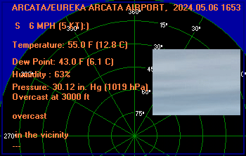
ARCATA/EUREKA ARCATA AIRPORT, CA, United States (KACV) 40-59N 124-06W 67M
Apr 26, 2024 - 07:34 AM EDT / 2024.04.26 1134 UTC
Wind: from the S (190 degrees) at 5 MPH (4 KT):0
Visibility: 8 mile(s):0
Sky conditions: overcast
Weather: light rain
Precipitation last hour: 0.01 inches
Temperature: 50.0 F (10.0 C)
Dew Point: 50.0 F (10.0 C)
Relative Humidity: 100%
Pressure (altimeter): 30.03 in. Hg (1016 hPa)
ob: KACV 261134Z AUTO 19004KT 8SM -RA BKN003 OVC009 10/10 A3003 RMK AO2 RAB09 P0001 T01000100
cycle: 11
ALBUQUERQUE INTERNATIONAL AIRPORT, NM, United States (KABQ) 35-02N 106-36W 1618M
Apr 26, 2024 - 06:52 AM EDT / 2024.04.26 1052 UTC
Wind: from the WSW (250 degrees) at 7 MPH (6 KT):0
Visibility: 10 mile(s):0
Sky conditions: partly cloudy
Temperature: 50.0 F (10.0 C)
Dew Point: 33.1 F (0.6 C)
Relative Humidity: 51%
Pressure (altimeter): 29.9 in. Hg (1012 hPa)
ob: KABQ 261052Z 25006KT 10SM FEW045 FEW060 SCT075 10/01 A2990 RMK AO2 SLP068 MTN TOPS OBSC NE T01000006
cycle: 11
CHARLOTTE/DOUGLAS INTERNATIONAL , NC, United States (KCLT) 35-13N 80-57W 220M
Apr 26, 2024 - 06:52 AM EDT / 2024.04.26 1052 UTC
Wind: from the ENE (070 degrees) at 13 MPH (11 KT):0
Visibility: 10 mile(s):0
Sky conditions: overcast
Temperature: 57.0 F (13.9 C)
Dew Point: 48.9 F (9.4 C)
Relative Humidity: 74%
Pressure (altimeter): 30.26 in. Hg (1024 hPa)
ob: KCLT 261052Z 07011KT 10SM OVC020 14/09 A3026 RMK AO2 SLP256 T01390094
cycle: 11
Las Cruces, Las Cruces International Airport, NM, United States (KLRU) 32-17-22N 106-55-19W
Apr 26, 2024 - 07:35 AM EDT / 2024.04.26 1135 UTC
Wind: from the W (270 degrees) at 9 MPH (8 KT):0
Visibility: 10 mile(s):0
Sky conditions: clear
Temperature: 48.9 F (9.4 C)
Dew Point: 24.4 F (-4.2 C)
Relative Humidity: 37%
Pressure (altimeter): 29.92 in. Hg (1013 hPa)
ob: KLRU 261135Z AUTO 27008KT 10SM CLR 09/M04 A2992 RMK AO2 T00941042
cycle: 11
Eastsound, Orcas Island Airport, WA, United States (KORS) 48-42-29N 122-54-37W
Apr 26, 2024 - 07:35 AM EDT / 2024.04.26 1135 UTC
Wind: Calm:0
Visibility: 6 mile(s):0
Sky conditions: overcast
Weather: light rain; mist
Temperature: 50 F (10 C)
Dew Point: 50 F (10 C)
Relative Humidity: 100%
Pressure (altimeter): 29.75 in. Hg (1007 hPa)
ob: KORS 261135Z AUTO 00000KT 6SM -RA BR FEW005 BKN042 OVC055 10/10 A2975 RMK AO2
cycle: 11
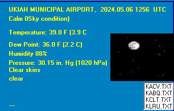
UKIAH MUNICIPAL AIRPORT, CA, United States (KUKI) 39-08N 123-12W
Apr 26, 2024 - 06:56 AM EDT / 2024.04.26 1056 UTC
Wind: Calm:0
Visibility: 10 mile(s):0
Sky conditions: overcast
Precipitation last hour: A trace
Temperature: 53.1 F (11.7 C)
Dew Point: 46.9 F (8.3 C)
Relative Humidity: 79%
Pressure (altimeter): 30.03 in. Hg (1016 hPa)
ob: KUKI 261056Z AUTO 00000KT 10SM BKN012 OVC021 12/08 A3003 RMK AO2 RAB25E34 SLP163 P0000 T01170083
cycle: 11
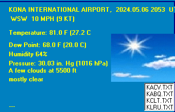
KONA INTERNATIONAL AIRPORT, HI, United States (PHKO) 19-44N 156-03W 27M
Apr 26, 2024 - 06:53 AM EDT / 2024.04.26 1053 UTC
Wind: from the SSE (150 degrees) at 8 MPH (7 KT):0
Visibility: 10 mile(s):0
Sky conditions: overcast
Temperature: 77.0 F (25.0 C)
Dew Point: 68.0 F (20.0 C)
Relative Humidity: 73%
Pressure (altimeter): 30.08 in. Hg (1018 hPa)
ob: PHKO 261053Z AUTO 15007KT 10SM OVC042 25/20 A3008 RMK AO2 SLP184 T02500200
cycle: 11
Use the RELOAD facility on your browser to retrieve the latest data.